| Cemetery Number | WK125 |
| Town | WARWICK |
| Cemetery Name | GENERAL THOMAS WESTCOTT LOT |
| Find A Grave (Opens in New Tab) |
Go to Find a Grave
|
| Graves List | Display Graves List |
| Location | PROVIDENCE ST (BEHIND #337) |
| State | RI |
| Direction | S |
| Pole Number | |
| Distance | 400 |
| Map Number | |
| Page Number | 253 |
| Plat Number | 23 |
| Deed Book | |
| Deed Page | |
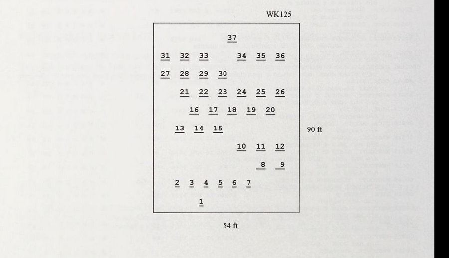
| Size in Feet | 54 |
| Size in Feet | 90 |
| Inscriptions | 38 |
| Fieldstones | 7 |
| Tombs | |
| Exist? | YES |
| Last seen date? | 2013 |
| Newest | 1946 |
| Oldest | 1751 |
| Vandalism | N |
| Veteran | 3 |
| Pole | N |
| Comment | This cemetery is located 400 ft south of Providence Street, southwest of the residence at #337. The cemetery is 54 ft x 90 ft, in good condition, enclosed with a stone wall. It contains 45 burials with 37 inscribed stones and 7 fieldstones. It is on the tax assessor’s map, Plat #253, Lot #23.
James Arnold visited this lot 12 June 1892 and noted, “at Westcott Station northeast of the Providence railroad, a short distance northwest from the house in side hill. Wall faced and cemented” (Vol. 1, p. 239). Also in the Arnold collection is a recording done in the 1930s by Arthur James, Vol. 29, p. 220. It was recorded by Benns, their #651, “at toll gate house.”
Several gravestones, including those of General Westcott and his wife, were moved from the Marble Family burial ground (WK039) at Nausauket.
Found, registered and recorded by John Sterling for a book on Warwick cemeteries. |
| Condition | good |
| Enclosure | stone wall |
| Gate | wooden gate |
| Growth | overgrown-trees |
| Terrain | hilly steep |
| Cemetery Location |
|
| Cemetery Burial Map |
|
| |
|