| Cemetery Number | CY006 |
| Town | COVENTRY |
| Cemetery Name | GIBBS-WESTCOTT LOT |
| Find A Grave (Opens in New Tab) |
Go to Find a Grave
|
| Graves List | Display Graves List |
| Location | PLAINFIELD PIKE |
| State | RI |
| Direction | S |
| Pole Number | 125 |
| Distance | 20 |
| Map Number | 320 |
| Page Number | |
| Plat Number | 5 |
| Deed Book | |
| Deed Page | |
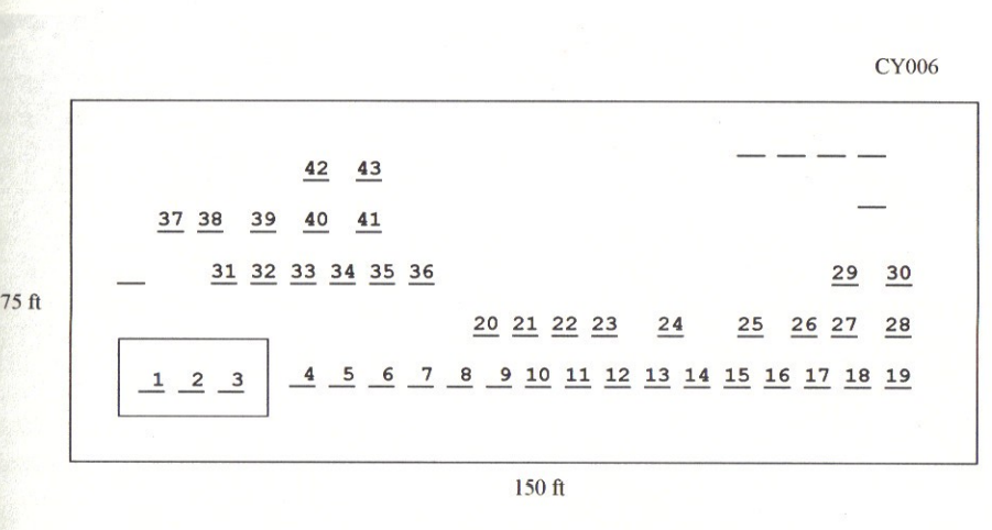
| Size in Feet | 150 |
| Size in Feet | 75 |
| Inscriptions | 43 |
| Fieldstones | 6 |
| Tombs | 0 |
| Exist? | YES |
| Last seen date? | 2013 |
| Newest | 1895 |
| Oldest | 1782 |
| Vandalism | N |
| Veteran | 5 |
| Pole | G |
| Comment | The Gibbs-Westcott is located 20 feet south of Plainfield Pike at telephone pole #125. It is 150 ft x 75 ft, in fair condition, and enclosed with a stone wall. The historic cemetery sign is in good condition. There are 51 burials with 43 inscribed stones and six fieldstones. It is on the tax assessor’s map #313, Lot #5.
James N. Arnold visited this lot on August 8, 1905 and noted, “Beside the road on Plainfield Pike and nearly opposite from the McGregor house, a burial lot, walled. Wall and lot in good order, three graves are protected by granite posts and iron rails” [first 3 Gibbs] (Vol. 6, Book B, page 1133). It was recorded by the Benns in 1933, their #147.
Recorded by Dr. Bill Eddleman and John Sterling for a 1998 book. |
| Condition | fair |
| Enclosure | stone wall |
| Gate | no gate |
| Growth | overgrown-trees |
| Terrain | hilly moderate |
| Cemetery Location |
|
| Cemetery Burial Map |
|
| |
|