| Cemetery Number | SM088 |
| Town | SMITHFIELD |
| Cemetery Name | HIRAM MASON LOT |
| Find A Grave (Opens in New Tab) |
|
| Graves List | Display Graves List |
| Location | ROCKY HILL ROAD |
| State | RI |
| Direction | E |
| Pole Number | 37 |
| Distance | 400 |
| Map Number | |
| Page Number | |
| Plat Number | |
| Deed Book | |
| Deed Page | |
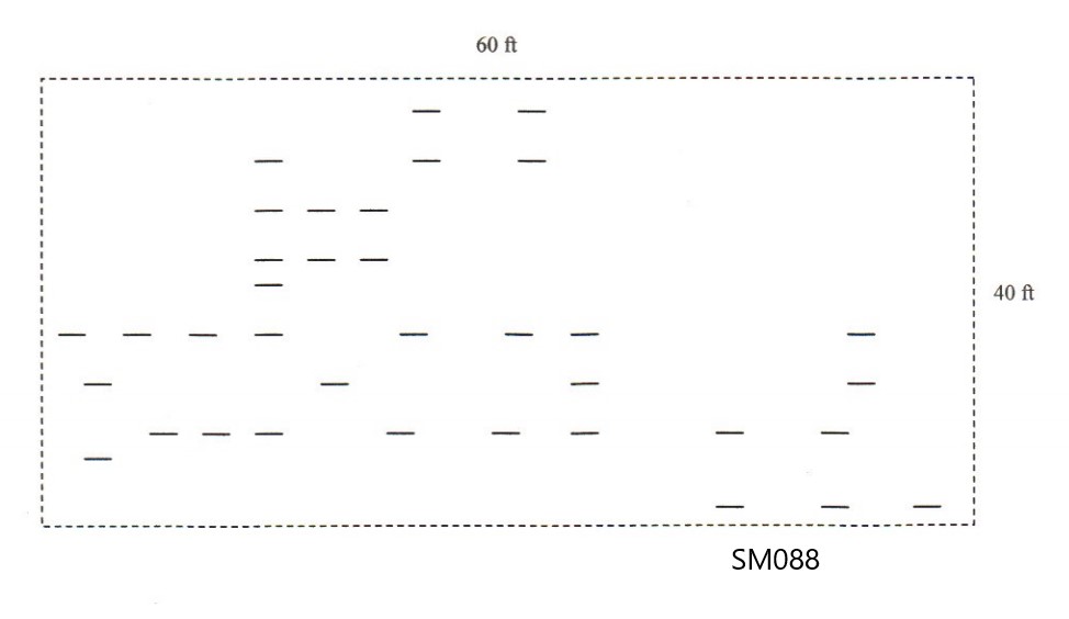
| Size in Feet | 60 |
| Size in Feet | 40 |
| Inscriptions | 0 |
| Fieldstones | 30 |
| Tombs | |
| Exist? | YES |
| Last seen date? | 2015 |
| Newest | |
| Oldest | |
| Vandalism | |
| Veteran | |
| Pole | N |
| Comment | Transcribed by James N Arnold (Vol 25, page 392). He describes lot as
follows:
"On farm belonging to William A Howard, adjoining the William Mowry farm, in open lot & unprotected."
Transcribed by Ethel M. White. "Near Reservoir, Smithfield. One stone with inscription, several gravs with rude field stones. In the woods, unprotected."
Transcribed by Irene Nebiker in the early 1970's.
Registered by Roger Beaudry November, 1996
Transcribed by Roger Beaudry May 1, 1999. Cemetery can be found by travelling 3/10 of a mile past telephone pole #37. On right is a path which leads to the Woonsocket Reservoir. Follow path about 600 ft. Before you cross over a brook on the left is a small hill. Climb hill about 100 ft to stone wall. Past stone wall about 250 ft the land will begin to slope down. the field stones can be found scattered on slope of hill. The area of the lot is guessed at based on the rough area covered by the fieldstones.
Cemetery can be found by taking the Woonsocket Water Dept Reservoir Service Rd North from Rocky Hill Rd. Go past the remains of the William Mowry Farm on the right. When you crest the hill that overlooks Crookfall Brook, turn West into the
Woodline. Cross over the stonewall. Continue West about 200 ft to the top of the hill. The field stones can be found scattered on slope of hill. The area of the lot is guessed at based on the rough area covered by the fieldstones Lot was formerly SM88. Based on GPS, lot is in NS. |
| Condition | fair |
| Enclosure | no enclosure |
| Gate | |
| Growth | overgrown-trees |
| Terrain | hilly moderate |
| Cemetery Location |
|
| Cemetery Burial Map |
|
| |
|