| Cemetery Number | SK157 |
| Town | SOUTH KINGSTOWN |
| Cemetery Name | JOSEPH CASE LOT |
| Find A Grave (Opens in New Tab) |
|
| Graves List | Display Graves List |
| Location | MOORESFIELD RD. - RT. 138 |
| State | RI |
| Direction | S |
| Pole Number | 110 |
| Distance | 1650 |
| Map Number | |
| Page Number | |
| Plat Number | |
| Deed Book | |
| Deed Page | |
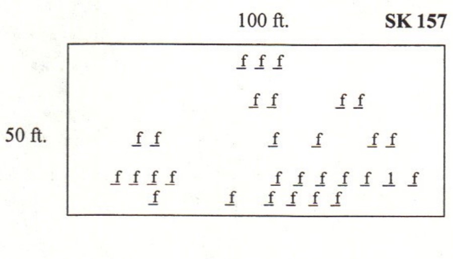
| Size in Feet | 100 |
| Size in Feet | 50 |
| Inscriptions | 1 |
| Fieldstones | 44 |
| Tombs | |
| Exist? | YES |
| Last seen date? | 2003 |
| Newest | 1739 |
| Oldest | 1739 |
| Vandalism | N |
| Veteran | |
| Pole | N |
| Comment | This cemetery is located on the Audubon property, Kingston Wildlife Research Center, at #1640 Mooresfield Road, 1,650 feet south of Mooresfield Road at telephone pole #110. Follow the trail just north of the house for about five hundred feet until it turns south. The cemetery is north of this turn in the trail. It is triangular in shape where the east wall meets the west wall at the north end of the cemetery. It is one hundred by fifty feet, in good condition, enclosed with a stone wall, and there is no historical cemetery sign. We counted 31 fieldstone marked graves, but Arnold counted 44 in 1880.
James N. Arnold visited this cemetery Mar. 21, 1881, his #278, “on land of John V. Northup east of his house lot overgrown with briers and locust a burial yard of the Case family.”
Found, registered, and recorded by John Sterling & James Wheaton for a 2004 book on South Kingstown cemeteries. |
| Condition | good |
| Enclosure | stone wall |
| Gate | no gate |
| Growth | overgrown-trees |
| Terrain | level |
| Cemetery Location |
|
| Cemetery Burial Map |
|
| |
|