| Cemetery Number | SK147 |
| Town | SOUTH KINGSTOWN |
| Cemetery Name | JOSHUA TUCKER LOT |
| Find A Grave (Opens in New Tab) |
Go to Find a Grave
|
| Graves List | Display Graves List |
| Location | MINISTERIAL RD |
| State | RI |
| Direction | E |
| Pole Number | 146 |
| Distance | 1600 |
| Map Number | |
| Page Number | 67 |
| Plat Number | 9 |
| Deed Book | |
| Deed Page | |
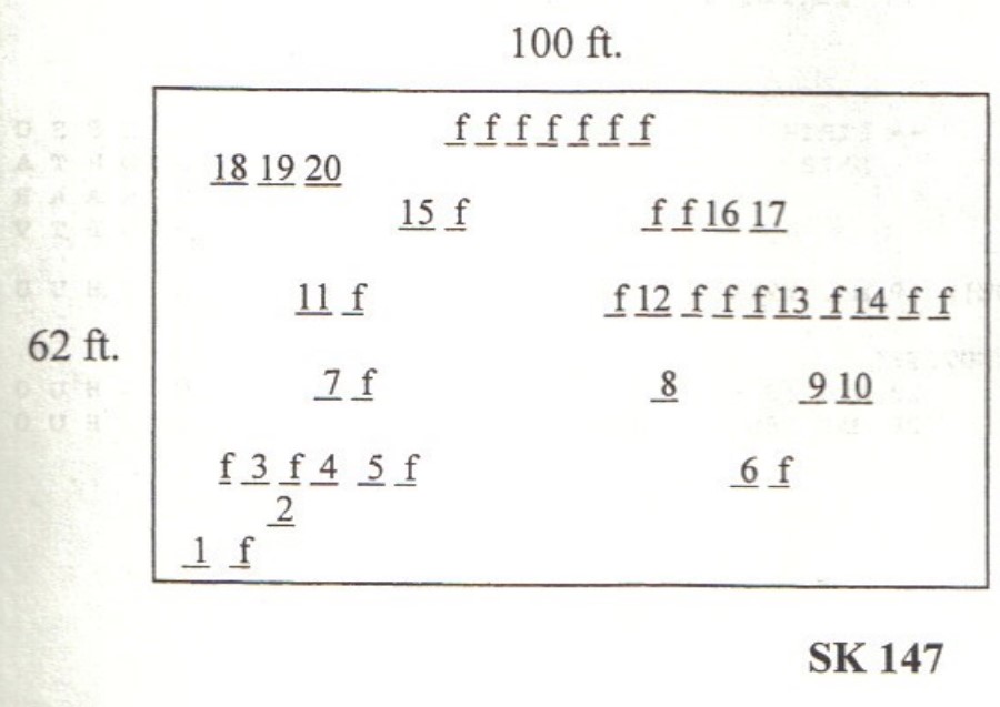
| Size in Feet | 100 |
| Size in Feet | 62 |
| Inscriptions | 24 |
| Fieldstones | 46 |
| Tombs | |
| Exist? | YES |
| Last seen date? | 2003 |
| Newest | 1934 |
| Oldest | 1823 |
| Vandalism | N |
| Veteran | |
| Pole | N |
| Comment | This cemetery is located 1,600 feet east of Ministerial Road at telephone pole #146. Follow the paved drive to #839A Ministerial Road, opposite telephone pole #146, east for 0.3 miles to the end. This is the Charles B. Perkins house overlooking Tucker Pond. Southeast of the house is the cemetery on a hill across a pasture enclosed with a stone wall. It is 100 feet x 62 feet, in good condition, enclosed with a stone wall; there is no historical cemetery sign. There are 69 burials with 24 inscribed stones and 46 fieldstones. In 2003 eight buried stones—map numbers 2, 7, 11, 16, 17, 18, 19, and 20—could only be found by probing and digging. This cemetery is shown on Plat map #67 between lot 5 and lot 6.
James N. Arnold recorded this lot Oct. 6, 1880, his #135, “on land of Joseph H. Tucker south of house, lot walled in a burial yard of his family. Only 24 of the 46 fieldstones found by Arnold could be found in 2003.
Found, registered, and recorded by John Sterling & James Wheaton for a 2004 book on South Kingstown cemeteries. |
| Condition | good |
| Enclosure | stone wall |
| Gate | no gate |
| Growth | overgrown-weeds |
| Terrain | |
| Cemetery Location |
|
| Cemetery Burial Map |
|
| |
|