Rhode Island Historical Cemeteries
Home
Members
Events
Meetings/Minutes
Database
FAQ/Documents
Links
Groups/Associations
Contact
FEATURED CEMETERY PHOTO
Photo/Image Courtesy of Rhode Island Historic Cemetery Volunteers
Cemetery Number
SK115
Town
SOUTH KINGSTOWN
Cemetery Name
CALEB HAZARD LOT
Find A Grave (Opens in New Tab)
Go to Find a Grave
Graves List
Display Graves List
Location
OLD POST RD - ROUTE #1A
State
RI
Direction
E
Pole Number
239
Distance
1450
Map Number
Page Number
Plat Number
Deed Book
Deed Page
Size in Feet
20
Size in Feet
20
Inscriptions
2
Fieldstones
Tombs
Exist?
YES
Last seen date?
2003
Newest
1786
Oldest
1726
Vandalism
N
Veteran
0
Pole
N
Comment
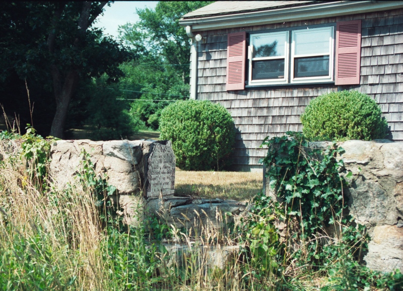
This cemetery is located 1450 feet east of Old Post Road at telephone pole #239. Follow the drive at telephone pole #239 that passes several houses, then passes north of Rum Pond. There is a small house on a hill just north of the road at the pond (the closest one to the pond). This house is #458C Old Post Road. The stones are fifty feet from the road in front of the house. Two of the stones are cemented into the wall at the steps, and a footstone into the wall on the north side. On top of the wall is a fragment of the Caleb Hazard Sr. gravestone. The cemetery exists only as these three stones. James N. Arnold visited this lot Oct. 16, 1880, his #189, “on land of Rev. E. F. Watson west of his house beside road in open lot and unprotected a burial yard. Think in all probability graves in this yard have been obliterated by the plow.” Found, registered, and recorded by John Sterling & James Wheaton for a 2004 book on South Kingstown cemeteries.
Condition
poor
Enclosure
no enclosure
Gate
no gate
Growth
grass-well kept
Terrain
hilly moderate
Cemetery Location
Cemetery Burial Map
N/A
ADDITIONAL CEMETERY PHOTOS/MAPS
 Photo/Image Courtesy of Rhode Island Historic Cemetery Volunteers