| Cemetery Number | SK097 |
| Town | SOUTH KINGSTOWN |
| Cemetery Name | SOLOMON CARPENTER LOT |
| Find A Grave (Opens in New Tab) |
Go to Find a Grave
|
| Graves List | Display Graves List |
| Location | AZELEA CIRCLE |
| State | RI |
| Direction | W |
| Pole Number | |
| Distance | 170 |
| Map Number | |
| Page Number | |
| Plat Number | |
| Deed Book | |
| Deed Page | |
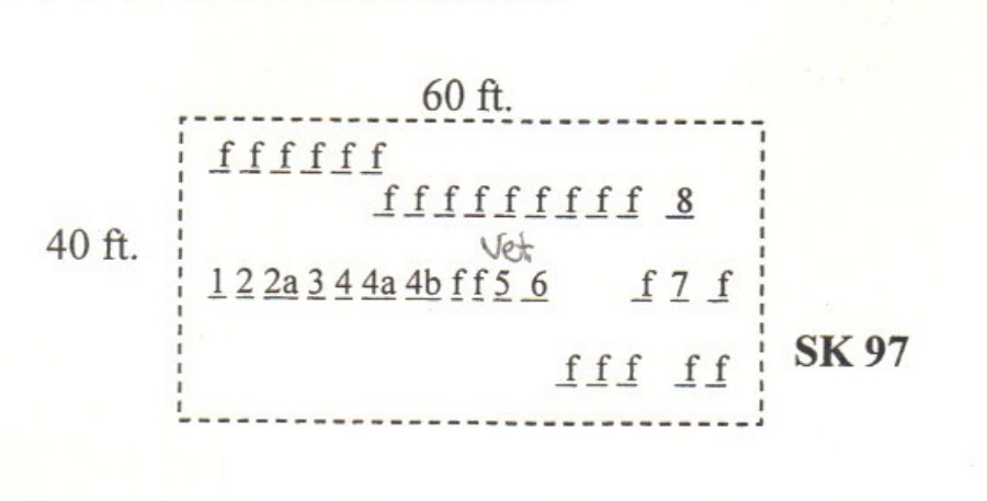
| Size in Feet | 60 |
| Size in Feet | 40 |
| Inscriptions | 8 |
| Fieldstones | 28 |
| Tombs | |
| Exist? | YES |
| Last seen date? | 2002 |
| Newest | 1868 |
| Oldest | 1787 |
| Vandalism | N |
| Veteran | |
| Pole | M |
| Comment | This cemetery is located 170 feet west of Azelea Circle behind house #70. It is also seven hundred feet east of South Road at telephone pole #106. It is about three hundred feet south of the house at #1443 South Road, the Solomon Carpenter house. It is sixty by forty feet, in good condition at the edge of the woods with no enclosure, and the historical cemetery sign is missing. It contains 36 burials with eight inscribed stones and 28 fieldstones.
James N. Arnold visited this lot Feb. 25, 1880, his #16, “on land now belonging to the Potter brothers a short distance from their farm house south, lot protected by stone wall, 20 large and 8 small graves with no markers save rude stones. This farm was taken up originally by the Carpenters and remained in their hands for several generations, being south of the Clarke lands, comprising originally several hundred acres. At the death of J. C. whose inscription we note the land was divided among his children. (note the Jeremiah Carpenter grandfather of one whose death we record above.)” Apparently Arnold was given information about this cemetery and about several of the fieldstone-marked graves that is shown below.
Registered in 1974 by Edwin Connelly
Recorded by John Sterling and James Wheaton for a 2004 book on South Kingstown cemeteries. |
| Condition | good |
| Enclosure | no enclosure |
| Gate | no gate |
| Growth | overgrown-trees |
| Terrain | level |
| Cemetery Location |
|
| Cemetery Burial Map |
|
| |
|