| Cemetery Number | SK063 |
| Town | SOUTH KINGSTOWN |
| Cemetery Name | JOHN BROWNING LOT |
| Find A Grave (Opens in New Tab) |
Go to Find a Grave
|
| Graves List | Display Graves List |
| Location | OLD POST RD |
| State | RI |
| Direction | S |
| Pole Number | 316 |
| Distance | 4500 |
| Map Number | |
| Page Number | |
| Plat Number | |
| Deed Book | |
| Deed Page | |
| Size in Feet | 85 |
| Size in Feet | 55 |
| Inscriptions | 33 |
| Fieldstones | 33 |
| Tombs | |
| Exist? | YES |
| Last seen date? | 2002 |
| Newest | 1924 |
| Oldest | 1832 |
| Vandalism | N |
| Veteran | |
| Pole | F |
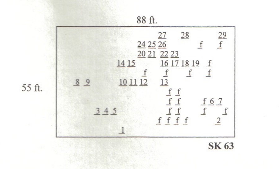
| Comment | This burial ground is located 310 feet west of Canterbury Road at the intersection with Bedford Street, behind #46 Canterbury Road. It is located 4,500 feet south of Old Post Road at telephone pole #316 (formerly #1510). Enter the paved drive through an opening in the stone wall, and go about 3/4 mile to the end of the drive at the farm house. The burial ground is five hundred feet south of the house. The property approaching the cemetery belongs to John Jackson, but the cemetery is actually south of his property in thick woods on property that has been recently developed for homes. It is 85 feet x 55 feet, in fair condition, enclosed with a stone wall with an iron gate, and the historical cemetery sign is in fair condition. There are 66 burials with 33 inscribed stones and 33 fieldstones. The fieldstone count comes from James N. Arnold. The briars, vines, and undergrowth made a complete count in 2002 impossible although twenty were located as shown on the map below.
James N. Arnold visited this lot Oct. 8, 1880, his #154, “the Browning burial yard lot well walled on land of George W. Browning south of his house.”
Recorded by John Sterling and James Wheaton for a 2004 book on South Kingstown cemeteries. |
| Condition | fair |
| Enclosure | stone wall |
| Gate | iron gate |
| Growth | overgrown-trees |
| Terrain | level |
| Cemetery Location |
|
| Cemetery Burial Map |
|
| |
|