Rhode Island Historical Cemeteries
Home
Members
Events
Meetings/Minutes
Database
FAQ/Documents
Links
Groups/Associations
Contact
FEATURED CEMETERY PHOTO
Photo/Image Courtesy of Rhode Island Historic Cemetery Volunteers
Cemetery Number
SK015
Town
SOUTH KINGSTOWN
Cemetery Name
NATHANIEL PERKINS LOT
Find A Grave (Opens in New Tab)
Go to Find a Grave
Graves List
Display Graves List
Location
LIBERTY LANE
State
RI
Direction
S
Pole Number
6750
Distance
240
Map Number
Page Number
Plat Number
Deed Book
Deed Page
Size in Feet
40
Size in Feet
40
Inscriptions
14
Fieldstones
0
Tombs
Exist?
YES
Last seen date?
2003
Newest
1936
Oldest
1766
Vandalism
N
Veteran
0
Pole
M
Comment
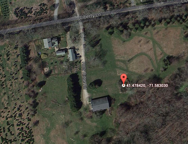
This cemetery is located two hundred forty feet south of Liberty Lane at telephone pole # 6750 and 130 feet east of Holly Ridge Road. Follow the driveway to #910 Liberty Road, and the cemetery will be found on the left or east side of the drive. It is forty feet square, in good condition, enclosed with a stone wall with unusual steps built into the wall. The historical cemetery sign was missing at the time of our visit. There are fourteen inscribed stones. James N. Arnold visited this yard Nov. 9, 1880, his #226, “on land of Jabez Perkins east of his house a burial yard of his family fenced only.” Recorded by John Sterling and James Wheaton for a 2004 book on South Kingstown cemeteries.
Condition
good
Enclosure
stone wall
Gate
no gate
Growth
cleared
Terrain
level
Cemetery Location
Cemetery Burial Map
ADDITIONAL CEMETERY PHOTOS/MAPS
 Photo/Image Courtesy of Rhode Island Historic Cemetery Volunteers