Rhode Island Historical Cemeteries
Home
Members
Events
Meetings/Minutes
Database
FAQ/Documents
Links
Groups/Associations
Contact
FEATURED CEMETERY PHOTO
Photo/Image Courtesy of Rhode Island Historic Cemetery Volunteers
Cemetery Number
SC126
Town
SCITUATE
Cemetery Name
MIAL SMITH LOT
Find A Grave (Opens in New Tab)
Go to Find a Grave
Graves List
Display Graves List
Location
ELMDALE ROAD
State
RI
Direction
E
Pole Number
Distance
360
Map Number
Page Number
Plat Number
Deed Book
Deed Page
Size in Feet
75
Size in Feet
45
Inscriptions
10
Fieldstones
1
Tombs
Exist?
YES
Last seen date?
Newest
1883
Oldest
1828
Vandalism
N
Veteran
Pole
N
Comment
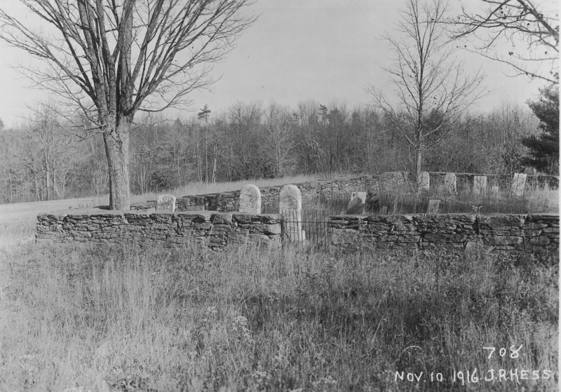
On the restricted reservoir property map A2-#742; photo #708 One of the nicest cemetery stone walls in town. The cemetery is located 550 feet north of Quaker Lane. The stone wall along the yard goes up over a ridge. At the highest point cross the stone wall and go 360 feet east to the cemetery. James N Arnold recorded this cemetery 25 Aug 1904 (Vol 2, Pg ) On road leading north from Elmdale on the Smith Farm east side of road back of orchard, lot walled, in fine order, yard same, a maple tree in each corner of lot.
Condition
good
Enclosure
stone wall
Gate
iron gate
Growth
overgrown-trees
Terrain
level
Cemetery Location
Cemetery Burial Map
N/A
ADDITIONAL CEMETERY PHOTOS/MAPS
 Photo/Image Courtesy of Rhode Island Historic Cemetery Volunteers