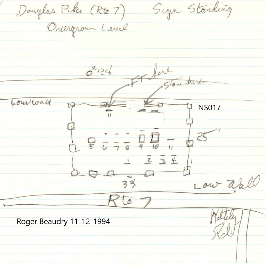
| Cemetery Number | NS017 |
| Town | NORTH SMITHFIELD |
| Cemetery Name | ELIJAH SMITH LOT |
| Find A Grave (Opens in New Tab) |
Go to Find a Grave
|
| Graves List | Display Graves List |
| Location | DOUGLAS PIKE (ROUTE 7) |
| State | RI |
| Direction | N |
| Pole Number | 128 |
| Distance | 10 |
| Map Number | 10 |
| Page Number | 10 |
| Plat Number | 184 |
| Deed Book | 134 |
| Deed Page | 995 |
| Size in Feet | 30 |
| Size in Feet | 35 |
| Inscriptions | 12 |
| Fieldstones | |
| Tombs | |
| Exist? | YES |
| Last seen date? | |
| Newest | 1903 |
| Oldest | 1805 |
| Vandalism | N |
| Veteran | |
| Pole | G |
| Comment | Transcribed by James N Arnold and listed in Volume 25, pages 291-293, under Smithfield. He described the cemetery as:
"On the Douglas Pike close to the corner of the Field Station road and in the sight of it, lot protected by iron rails and granite posts, wall and lot in good order. Stones all marble."
Transcribed by Charles & Martha Benns (Vol III, page 393). They assigned it #497 and described lot as follows: "Smith Family, Burrillville."
NOTE: Burial yard is most definitely in North Smithfield, not Burrillville.
Transcription done by Ethel M White in the 1930's. "Side of road, Pine Crest Beach Road, Route 5. Small cemetery east side of Douglas Pike between railroad crossing and Burrillville town line, North Smithfield,
RI."
Transcribed by Irene Nebiker in the early 1970's.
Cemetery transcribed by Roger Beaudry on November 12, 1994. At that time it sat atop a very low wall running parallel to the street. It is overrun with high weeds and some stones are down.
Cemetery is mapped out in the land records located in the North Smithfield Town Hall.
Transcribed by Ron Farrar circa 1970. "Douglas Pike, N East of Mattity Road." |
| Condition | poor |
| Enclosure | granite posts/iron rails |
| Gate | no gate |
| Growth | overgrown-weeds |
| Terrain | level |
| Cemetery Location |
|
| Cemetery Burial Map |
|
| |
|